The plan for the second day was simple, ride from Killin to Balloch along the NCN 7 and then catch a train home. However, before the end of breakfast, the plan had started to change. Having looked at the maps the night before we were aware the next section of the NCN 7 is routed along a lot of off-road cycle tracks. From experience, we knew that these Sustrans off road tracks are often poorly surfaced and slow going, so we decided to ride as far as Callander, then decide whether book accommodation in Aberfoyle or Drymen, depending how we were doing. Also, as we were spending another night on the road, we would extend the ride beyond Balloch as the end point. So therefore, the ride became Tay to the Clyde and we were going to end at Glasgow Queen’s Street.
Breakfast over and photos taken, we set out on the road once more. Over the Falls of Dochart, briefly stopping for photos this time, then turning off-road and following an old railway line. If there is one thing that riding on Sustrans cycle route network shows you, it is the extent of the Scottish railway network pre the 1960’s. That was when Harold Macmillan’s Conservative government decided that the British people didn’t need public transport any more, not surprising as he had a ministerial car and the transport minister, Ernest Marples, was the director of a road-construction company. To justify the wholesale destruction of the rail network, they commissioned Dr Richard Beeching (a physicist) to write a report, which he did in the space of a week. He was richly rewarded for this with a salary £14,000 greater than the Prime Minister’s (that is £214,000 in today’s money), and a life peerage as Baron Beeching of East Grinstead. This had a devastating effect on transport in rural Scotland which is still being felt today. But I digress. We rode along the old railway line through dappled sunlight, with moss covered concrete sleepers stacked neatly at the side, looking as if they were just waiting to be re-laid.
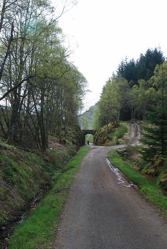
The route then turned off the railway line and headed uphill, thankfully, after a short time the path went from rough to tarmac. This wound its way up through the woods, before arriving at a gate with a car park beyond. There was a sign telling cyclists to dismount and walk across the road (A85). These signs always strike me as being utterly pointless, so we just treated the crossing as a crossroads and rode across. On the far side there was a gate and a sort of miniature cattle grid, it was just wide enough to ride across in comfort. Then we were onto another old railway line, shortly after Lochan Lairig Cheile we crossed the watershed into Glen Ogle.
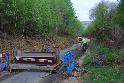
Further down the glen we came across ongoing path maintenance:
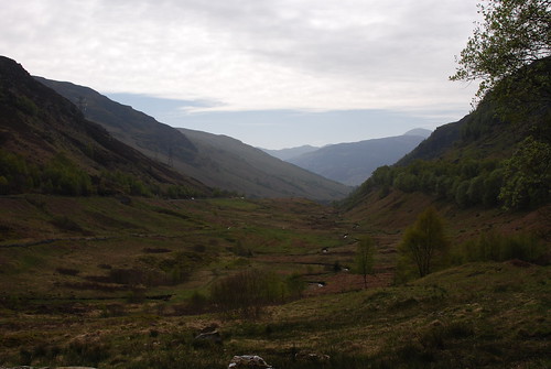
As you reach the end of Glen Ogle, views of Loch Earn start to open up. So that you can make the most of these views, the route directs you off the old railway and down a steep set of hairpin bends (to another old railway line). At least I assume that is why Sustrans directs you off the higher railway line to one 70m lower, looking at the map the two lines meet up just above the old Balquhidder station. Why the route doesn’t stay on the higher line, with the option of a spur going off to Lochearnhead for those wanting to visit the village, I don’t know, but it would be a better option than the steep set of hairpin bends. At least this section of the route is metalled, which is more than can be said for much of what came next.
We followed the lower old railway over a bridge crossing the Kendrum Burn on which there was a memorial to a cyclist who was killed on the A9. The old railway crossed the main road (A84), but the cycle route stays on the north side and continues off road through the woods past old Balquhidder station, then picks up the Kingshouse to Balquhidder road.
You are now in the heartlands of an infamous character known, in his own time, as Robby the sheep (although not to his face). Red Robert (or Raibeart Ruadh, if you prefer the Gaelic) was variously a sheep trader and respected cattleman, a solder and a rent collector (after a fashion). This was back in the days when cattle-reiving (stealing) was a national sport. He initially made his name while still a teenager, in 1690 he recovered 15 beasts which belonged to the Earl of Breadalbane and had been stolen by the MacRaes of Kintail. This gained him respect and the patronage of other landowners who wanted their cattle protected. Unfortunately, not all landowners agreed with paying for protection of their cattle, and when young Robert picked up 200 cattle belonging to Earls of Callander and Linlithgow in 1691 it caused a scandal, reminding the Scottish Government that it did not control the Highlands.
As a recognition of his evident talents, Archibald Kilmanan (his clan chief) granted him some land around Inversnaid by Loch Lomond. Robert, raising money through his (legitimate) sheep dealing activities, was able to buy large areas of land on the east side of the loch. Just when he thought things were going well, he had a wee falling out with his neighbour James Graham, the fourth Marquess and first Duke of Montrose. This led to his lands being seized and him being declared an outlaw. However, he was able to call in a favour from Campbell, Earl of Breadalbane, who gave him a cottage in Campbell territory, out of the reach of Montrose. Robert then took to collecting rent from Montrose’s tenants, and even on one occasion paying the rent of a widowed tenant (then relieving the factor of the money later).
In 1715 Robert recruited supporters for the Jacobite rising in that year, but seems to have had second thoughts about it, as he and his men stood by and watched the battle of Sheriffmuir, refusing to take part. After the rising failed, Robert was accused of treason, but was given protection by the Duke of Argyll. Then in 1717 he was caught by Montrose at Balquhidder, and was being taken to Stirling for trial when he escaped while fording a river, distracting his pursuers by throwing his plaid into the river. After this incident, Montrose abandoned his attempts to persecute Robert, but others did not. He was taken prisoner, after being tricked by the first Duke of Atholl, who needed to demonstrate his loyalty to the Crown. Robert was imprisoned in Logierait Castle, but once again escaped.
There was a further Jacobite rising in 1719, this time Robert took part and was injured in the battle of Battle of Glen Shiel. Following the failure of this uprising, he went into hiding in Glen Shira, then later returned to Balquhidder. He was persuaded to petition General Wade (who was busy using the army to build roads all over Scotland to try and keep order) for a King’s pardon. A pardon was granted in 1725. Robert then carried on his cattle business for the rest of his life. He died in 1734, peacefully in his bed, at the age of 63 and is buried in the churchyard in Balquhidder. Should you wish to visit his grave as you pass, it is easy to find, just look for the grave of Rob Roy McGregor.
Anyway, back to the ride, having managed to get passed Balquhidder church, I was persuaded to stop to take photos of Loch Voil, just as I was about to take a run at the humpback that is Stronvar Bridge. Photos taken, over the bridge and we were headed back the glen we had just come along, only on the other side. As we turned the corner into Strathyre at Stroneslaney, there was a local man standing outside his house who waved and said hello. Evidently he regarded the appearance of cycle tourists rather like the arrival of swallows, a sign of approaching summer. It was a pleasant, quiet road, almost traffic free. Most people use the main road on the other side of the glen and don’t even know that this road exists. Sadly, just after Sidheag the hard top ran out and we were back onto the rough stuff again. Still, we did have a view of the next loch, it is not for nothing that the NCN 7 is called Lochs and Glens Cycle Route. This time it was Loch Lubnaig. As the track started to descend, we met a touring tandem coming the other way, they told us there was a steep descent ahead, and sure enough there was. A few hundred metres further on, the route turned sharply downhill through a series of hairpin bends, but this time it was on a loose surface. This gives the adventurous cycle tourist the opportunity to test their power sliding technique (irrespective of whether they really want to). Going up on a fully loaded touring bike can’t be much fun, as coming down was certainly interesting.
Along this lower track we started to meet a lot of leisure cyclists out for the day, indeed many were having picnics at the side of the track. There were also a few Heilan coos in the neighbouring fields, cue more photos. Towards the end of Loch Lubnaig we passed a collection holiday chalets and we were back on to the hard top, for a while at least. Once past the end of the loch, you find a car park for the Falls of Leny, beyond this we were back on a loose surface again. It continued this way, with exception of a road crossing, until we got to Callander.
Callander: time for lunch, but also decision time. Given the slow progress we were making, we decided to book accommodation in Aberfoyle and take another day. Well that bit was easy. Leaving Callander we decided to continue following the NCN 7 along the south side of Loch Venachar. We had ridden this part of the route before and knew what to expect until we got to the end of the loch, where the route turns south. At this point you turn on to the “forest drive“, a word of warning about this: although the route is off road, it is open to motor vehicles, and some drivers treat it as an opportunity to play at rally driving without regard for others.
The NCN 7 meanders it way through Achray Forest, it is very scenic and peaceful (for the most part, when there are no motor vehicles about), but it is not a easy option, compared to the Duke’s Pass. Now the Duke’s Pass does have a reputation for been a long hard climb, but the reason the road follows this route is because it is the path of least resistance. If you wanted to do the Duke’s Pass, you could follow the NCN 7 to where it turns south and away from the loch, but then continue westwards until you reach the road, then turn left. Or you could just follow the A821 out of Callander. We, having followed the NCN 7, passed Loch Drunkie (or Loch Drongaidh in Gaelic, meaning the loch between the ridges), then up and over the watershed. As we were coming down the south side, we turned a corner and saw a strange sight: there were platforms up in the trees and wires between them. This turned out to be the “Go Ape tree-top adventure”, which includes Britain’s longest zip wire at 426m.
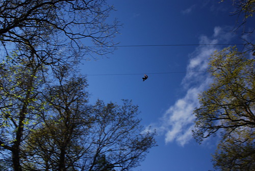
Sorry, but I am about to digress again, this zip wire is significantly longer than the piddling 230m one in Cornwall, which makes the spurious claim that it is the “longest zip wire in Europe”. However, the Aberfoyle one is also far from being the “longest zip wire in Europe”, as there is one in the Italian Dolomites which is 3 km long!! Now, back to the ride. As we exited the forest, there were a pair of half gates leading onto the road which had been specially commissioned for the NCN7.
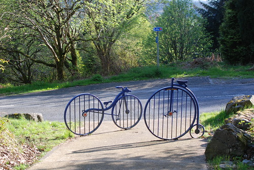
From the cycle gates it was a short downhill run into Aberfoyle, then over the humpbacked bridge to our B&B at Corrie Glen, where we were welcomed with tea and home baking, very nice it was too.
There is a map of our route here, and there is a slide show here (NB. this is for the whole trip and not in order).
My stats were:
- Distance cycled – 64.75 Km
- Time spent riding – 03:56:12
- Max Speed – 40.89 Km/h
- Ave Speed – 16.44 Km/h
- Vertical climb – ca. 640 m
Leave a Reply